Geology of the Barnett Shale
The Barnett Shale was deposited over a large part of North-Central Texas during the late Mississippian. During this period there was marine basin deposition of sediments (deposited under mostly anoxic conditions) before the formation of the Ouachita thrust foldbelt. The Barnett lies on the Ordovician limestone of the Viola-Simpson Formation and dolomites of the Ellenburger Formation. It is overlain by the carbonates and shales of the Pennsylvanian-age Marble Falls Group (Bruner, et al.).

(Montgomery, et al.) Figure 1 (above) shows a generalized stratigraphic column for the Fort Worth Basin including the Barnett Shale
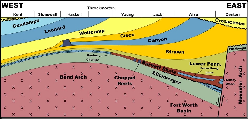
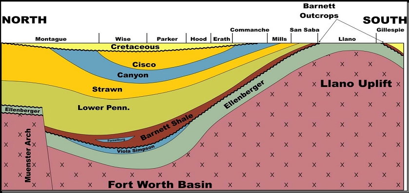
(Jarvis, et al.) Figure 2 (above) is a west to east and a north to south stratigraphic cross-section of the Fort Worth Basin showing the Barnett Shale.
This Barnett Shale is very unique because the source rock, reservoir rock, and trap coincide in the same formation. Production is mainly confined to a limited portion of the northern basin where the Barnett Shale is relatively thick (greater than 300 feet), organic rich (the present-day total organic carbon is greater than 3%), thermally mature (vitrinite reflectance is greater than 1.1%), and enclosed by dense limestone units which are able to contain induced fractures. The most actively drilled area is the Newark East field, which is currently the largest gas field in Texas (Montgomery, et al.).

(Bruner, et al.) Figure 3 (above) is an Isopach map of the Barnett Shale demonstrating thickness.

(Pollastro, et al.) Figure 4 (above) is a petroleum system events chart.
The Barnett Shale has been known to have a very low natural permeability and porosity (in the 0.5-0.6% range). This has resulted in oil companies using artificial methods of stimulation such as hydrofracking to acquire resources, especially gas, from this reservoir. (Bruner, et al.).
The regional extent of the Barnett Shale in the basin is controlled by the Red River-Muenster arch and Ouachita structural front to the north and east. It is also controlled by erosional pinch-out or facies changes to the west, on the Eastern Shelf. The Barnett Shale is present in the Midland, Delaware, and Palo Duro Basins to the west.

(Pollastro, et al.) Figure 5 (above) shows the regional extent of the Barnett Shale.
Compared to other gas-shale plays, the Barnett Shale is unique in several aspects:
- The Barnett produces from greater depths and, therefore, at higher pressures than do other gas-shale reservoirs.
- Barnett gas is entirely thermogenic in origin and, in large parts of the basin, occurs with liquid petroleum.
- The Barnett Shale has undergone a complex, multiphase thermal history, making geochemical considerations central to patterns of productivity. (Montgomery, et al.)
The size of the play is 9,000 square miles with a core area of 1,800 square miles. There is an estimated 39 trillion cubic feet (tcfg) of undiscovered, technically recoverable gas in the Barnett Shale (Bruner, et al.).
Maps showing the base of the lowest aquifer system overlying the Barnett Shale and the top of the underlying Ellenburger Group allow for an estimation of the distance between the zone of shale gas production and useful groundwater.

(Ryder) Figure 6 (above) shows the elevation with respect to sea level of the base of the lowest aquifer system overlying the Barnett Shale.

(Bruner, et al.) Figure 7 (above) shows the elevation with respect to sea level of the top of the Ellenburger Group underlying the Barnett Shale.
Geology of the Marcellus Shale
The Marcellus Shale is located in the Northeastern part of the United States. It was deposited during the Devonian Period when Acadian mountains provided sediments during the Acadian orogeny.

(Soeder, et al.) Figure 8 (above) shows the Marcellus Shale depositional environment during the Devonian Period.
The sediments were deposited in an ancient river delta, the Catskill Delta, and transported and accumulated under anoxic conditions in the Appalachian Basin. The basin floor subsided due to the heavy weight of the sediments, resulting in the wedge-shaped deposit that makes it thicker in the east.

(Bruner, et al.) Figure 9 (above) is an Isopach map of the Marcellus Shale demonstrating thickness.
The thickness of the Marcellus Shale varies from 50 to 660 feet. It has a vitrinite reflectance of 1.6-3.5% and the total organic carbon ranges from 1% to 11%. The Marcellus Shale also has tiny pore spaces (low permeability), so artificial stimulation techniques such as hydrofracking are employed to produce gas from this formation.

(Bruner, et al.) Figure 10 (above) shows well locations in the Marcellus.
The Marcellus Shale is a black shale that may contain limestone beds and concentrations of pyrite (FeS2) and siderite (FeCO3). It is fissile (like most shales, it tends to split along the bedding plane). It also contains uranium.
Like the Barnett, the Marcellus is also its own source rock, reservoir rock, and trap. It extends from New York through Pennsylvania to West Virginia, and westward from Maryland to Ohio. It is also found in Southern Ontario, Canada, and western New Jersey.

(Soeder, et al.) Figure 11 (above) shows the regional extent of the Marcellus Shale.
The regional extent of the Marcellus Shale makes it very difficult to give a specific name to the formation or find a similar formation that underlies and overlies the Marcellus. This is because the different names of the formations and the variation of the formations from region to region. The Marcellus is underlain by limestone to the north and by lower organic shale to the south.

(USGS) Figure 12 (above) shows generalized stratigraphic columns over the regional extent of the Marcellus Shale.
The size of this play is 75,000 square miles with a core area of 53,000 square miles. There is an estimated 50 trillion cubic feet (tcfg) of undiscovered, technically recoverable gas in the Marcellus Shale (Bruner, et al.).
Compare/Contrast of the Barnett and Marcellus Shales:
Similarities:
- In terms of geology, both shales were collected in forereef basins created along the convergent boundaries of tectonic plates
- The thrust-fault belt of the Barnett Shale corresponds to the Ouachita belt. The thrust-fault belt of the Marcellus Shale corresponds with the Appalachian belt.
- The structural arch of the Barnett corresponds with the Lampassas structural bend and the structural arch of the Marcellus corresponds with the Cincinnati structural bend. This influenced thickness patterns of the formations overlying the shales and of the shales themselves.
- Both were uplifted in a similar fashion.
- After both shales were deposited, each basin was filled with roughly 10,000 feet of post-orogenic sediments.
- In both shales, a number of structures are similar and were reactivated during orogenic deformations.
- There are major faults in both shales: the Mineral Wells and Rome faults in the Barnett Shale and the Clarendon-Linden in the Marcellus Shale
- Both consist of organic-rich shale and limestone. The Barnett consists of dense-organic-rich-soft-thin bedded-petroliferous-fossiliferous shale, and hard-black-finely-crystalline-petroliferous limestone. The Marcellus Shale consists of soft-to-moderate, gray to brownish carbonaceous, highly radioactive shale with beds of limestone and carbonate concretions (Bruner, et al.).
- Mineral compostions are similar for both. Geologists in both shale formations routinely identify similar rock types.
- Both shales also have a set of natural fractures.
Differences:
- The Fort Worth Basin was bordered by an island arc system which helped supply very little coarse-grained sediments to the Barnett.
- The Appalachian Basin borders a raised tectonic highland, thus supplying the Marcellus Shale with coarse-grained clastics on nearshore environments.
- Limestone beds of the Barnett were formed from mass-gravity flow which were collected by surrounding carbonate platforms (Bruner, et al.).
- Limestone beds in the Marcellus were produced when sea level dropped and also produced in anaerobic conditions.
- Karst in the Ellenburger Group is a factor in the Barnett Shale.
- Karst is not influential in the Marcellus Shale.
Comments (2)
Jonathan Price said
at 10:12 pm on Nov 30, 2011
And I completely agree with the difficulty in constraining the units above/below the Marcellus Shale. In the northeast, the slightest change in either composition or chronostratigraphic position warrants a whole new formation name (not to mention colloquial disputes over type localities). And you can't take the strat column to Canada. Not that we're exempt here - the Ellenburger suddenly becomes the Simpson Group at the Red River. In general, the Marcellus is underlain by lower-organic shales in the north and limestones in the south, and overlain by a thick package that becomes upwardly dominated by non-marine sediments as part of the prograding delta wedge.
Jonathan Price said
at 10:16 pm on Nov 30, 2011
I got that backwards - the Marcellus is underlain by limestone in the north and lower-organic shale in the south (more open basin in the north, after all).
You don't have permission to comment on this page.